
The FCC National Broadband Map is one of the most powerful — and most misunderstood — tools available to rural Americans trying to understand their connectivity options and advocate for better internet in their communities. Launched in November 2022 as the most comprehensive broadband mapping effort in US history, the map determines where billions of dollars of federal broadband funding flows. If your address is incorrectly mapped as “served” when you actually have no adequate internet access, you may be locked out of funding priority that would bring infrastructure to your area. Understanding how to use the map, how to interpret what it shows — and critically, how to challenge inaccurate data — is essential knowledge for every rural resident in 2026. This complete guide explains everything.
In This Guide
- What Is the FCC Broadband Map?
- How to Use the Map: Step-by-Step
- Understanding Your Results
- Why the Map Is Often Wrong for Rural Areas
- How to File a Coverage Challenge
- Why Challenges Matter: The BEAD Connection
- Organizing Community Bulk Challenges
- Availability vs Adoption Data
- State Broadband Maps vs FCC Map
- Frequently Asked Questions
What Is the FCC National Broadband Map?
The FCC National Broadband Map at broadbandmap.fcc.gov is the federal government’s authoritative database of broadband internet availability across the United States, down to the level of individual addresses and locations. It is the product of the Broadband Funding Accuracy Act, which required the FCC to replace its previous county-level broadband reporting system (which was widely acknowledged to dramatically overstate coverage) with a far more granular location-by-location approach.
The map serves three interconnected functions:
- Public information tool: Anyone can look up any address to see which internet providers have reported offering service there, at what speeds, and using which technologies.
- Policy and funding basis: Federal broadband funding programs — most critically the $42.45 billion BEAD Program — use the map’s data to determine which locations are “unserved” or “underserved” and therefore eligible for infrastructure investment.
- Accountability mechanism: The challenge process allows anyone — individuals, local governments, community organizations — to dispute coverage claims that are inaccurate, creating a feedback mechanism that improves map accuracy over time.
How to Use the FCC Broadband Map: Step-by-Step
The map interface is more intuitive than most government tools but has several layers that require explanation to interpret correctly:
- Go to broadbandmap.fcc.gov. The site is optimized for desktop browsers but also functions on mobile devices.
- Enter your address in the search bar. Type your full address — house number, street name, city, state, and ZIP code. The map will zoom to your location and identify your specific address or location unit.
- Select your specific address if prompted. In areas with multiple units or rural routes, you may need to select your specific location from a dropdown list. Rural Route addresses may appear in different formats — try alternative address formats if your primary format doesn’t resolve.
- View the “Available Providers” list. On the right side of the screen (or below the map on mobile), a list of providers that have reported offering service at your location appears, showing download speed, upload speed, technology type, and latency for each reported service.
- Filter by technology type if desired. Use the filter controls to show only specific technologies (fiber, cable, fixed wireless, satellite, etc.) or to show only services above a specific speed threshold.
- Check the broadband status classification. The map classifies each location as “Served” (has access to broadband at 100/20 Mbps or higher), “Underserved” (25/3 to 100/20 Mbps), or “Unserved” (below 25/3 Mbps or no service). This classification directly determines BEAD eligibility.
Understanding Your Results
The map shows what ISPs have reported about their coverage — which is fundamentally different from what is actually available. Understanding this distinction is critical:
What “Available” actually means: A provider listed as offering service at your address has filed a regulatory form with the FCC stating that they are “able to provide” service to that location. This does not mean they have connected the location, are actively serving it, or can connect you within a reasonable timeframe at the stated speed. It means they have reported that the technology they use in your general area could theoretically reach your address.
The overreporting problem: ISPs have financial incentives to claim as large a coverage area as possible — more claimed coverage means less of their territory is eligible for government-funded competing infrastructure. The FCC’s previous reporting methodology (asking carriers to report coverage at the census block level — if they served any address in a block, the entire block was counted as served) resulted in massive overstatement. The new address-level methodology is far more accurate, but overreporting at the address level still occurs — some providers report coverage based on theoretical network topology models rather than actual service capability verification.
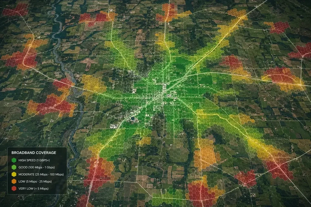
What the speed tiers mean:
- Below 25/3 Mbps or no service: “Unserved” — highest BEAD priority
- 25/3 to 100/20 Mbps: “Underserved” — second-highest BEAD priority
- 100/20 Mbps or higher: “Served” — generally not eligible for BEAD infrastructure funding
Why the Map Is Often Wrong for Rural Areas
Rural addresses are the most likely to have inaccurate coverage data in the FCC map, for several documented reasons:
- DSL speed overstatement: Legacy telephone companies often report rural DSL coverage at rated maximum speeds (6 Mbps, 10 Mbps, or even 25 Mbps) rather than actual delivered speeds at the line lengths involved. A rural address 3 miles from the nearest telephone switching equipment may be rated at 10 Mbps on paper but receives 1–3 Mbps in reality due to signal attenuation over long copper lines.
- Fixed wireless coverage overreach: Some rural WISPs and cellular carriers report fixed wireless coverage based on tower coverage radius models that don’t account for terrain obstruction, tree cover, or actual customer service feasibility.
- Satellite speed classification: Major satellite providers (HughesNet, Viasat) are classified as serving addresses at their maximum advertised speeds, which may be classified as “underserved” or even “served” despite the providers’ latency (600–800 ms) making the service functionally inadequate for modern internet applications. The FCC’s current map doesn’t fully account for latency as a service quality metric.
- Recently abandoned service: Some rural ISPs that have stopped actively offering service in an area may still appear in the map database if their coverage records haven’t been updated.
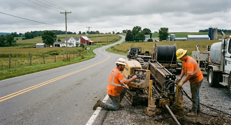
How to File a Coverage Challenge
Filing a challenge is the most impactful action any rural resident can take to improve broadband funding eligibility for their community. The process is designed to be accessible to non-technical users:
- Find your address on the broadbandmap.fcc.gov map and click on your location.
- In the provider list, find the provider whose coverage you want to challenge. Click “Challenge this availability.”
- Select the type of challenge you’re filing:
- Availability challenge: The provider claims to offer service at your address, but you cannot actually get service from them (they don’t serve your road, won’t connect you, or require prohibitive installation costs).
- Speed challenge: The provider serves your address but at speeds significantly below what they report (e.g., they report 10 Mbps DSL but you receive 1–2 Mbps).
- Technology challenge: The provider reports a technology type incorrectly.
- Provide supporting documentation. The most effective challenges include: a screenshot from the provider’s website showing your address is not serviceable, a letter of denial from the provider, speed test results documenting actual speeds (Speedtest.net tests are accepted), or a sworn statement that you attempted to order service and were denied.
- Submit the challenge. The FCC reviews challenges and notifies the provider, who has 60 days to respond. If the provider cannot substantiate their coverage claim, the FCC updates the map to reflect the challenged status.
The FCC’s challenge process documentation provides detailed instructions and accepted evidence types for each challenge category.
Why Challenges Directly Affect BEAD Funding
This is the most important practical implication of the map for rural communities: BEAD Program funds are allocated based on the map’s data. A rural address that is correctly mapped as “unserved” is eligible for infrastructure funding. A rural address incorrectly mapped as “served” — even if the “service” is theoretically available but practically inaccessible — may be excluded from BEAD-funded infrastructure deployment.
When a challenge is successfully resolved and an address moves from “served” to “unserved,” that address (and potentially its surrounding area) becomes newly eligible for BEAD infrastructure investment. At a community level, if dozens or hundreds of rural addresses in a county successfully challenge inaccurate coverage claims, the county’s total BEAD-eligible address count increases, making it more likely that ISPs will target that county for BEAD-funded deployment and more likely to receive a larger share of state BEAD funds.
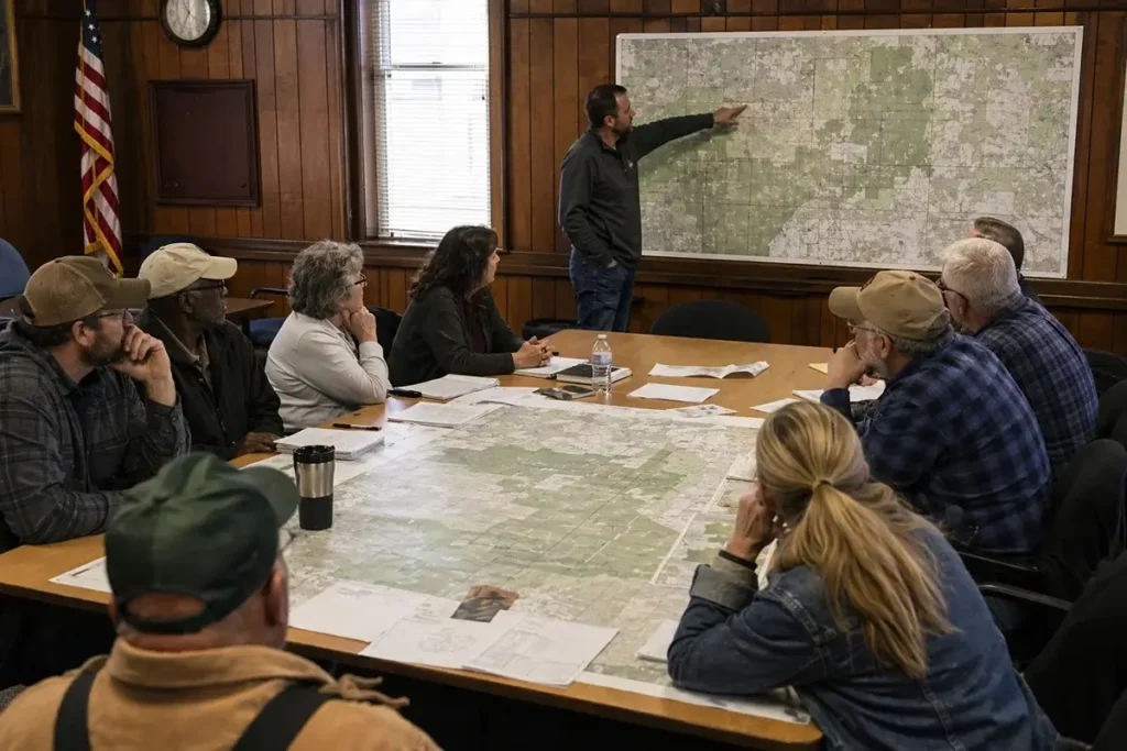
Organizing Community Bulk Challenges
Individual challenges are valuable, but organized community bulk challenges are far more effective at driving map corrections and attracting BEAD funding attention to underserved areas. Strategies for community challenge organizing:
- County government coordination: County commissioners and economic development offices have both the authority and the incentive to organize challenge campaigns on behalf of their rural constituents. Several state broadband offices actively encourage county governments to coordinate bulk challenges.
- Rural electric cooperative leadership: Electric cooperatives with broadband ambitions have strong incentives to ensure their member communities are correctly mapped as unserved, since map corrections increase the BEAD funding available to the co-op for infrastructure deployment.
- Community organizing through extension offices: County extension offices can serve as neutral organizational hubs for challenge campaigns, helping rural residents understand the process and submit challenges for their specific addresses.
- State broadband office programs: Many state broadband offices provide technical assistance for community challenge campaigns, including template letters, documentation guidance, and coordination with state and federal broadband staff.
Frequently Asked Questions
How long does an FCC broadband challenge take to resolve?
The FCC’s formal challenge resolution process gives providers 60 days to respond to challenges. After the provider’s response period, the FCC reviews the evidence and updates the map accordingly. Complete resolution of a challenge — from submission to map update — typically takes 3–6 months. Successful challenges that correct coverage data are reflected in subsequent map releases, which directly update the data used for BEAD funding allocation.
Can I use Starlink or HughesNet speed test results to challenge a provider’s claimed speeds?
Speed test results can support speed challenges against your existing provider, but they should reflect speed tests on the connection being challenged — not a different provider’s connection. To challenge a DSL provider’s claimed speed, you need speed tests showing actual delivered speed on that DSL connection. For availability challenges (where a provider claims to serve you but won’t actually connect you), provider denial documentation or their website showing your address as unserviceable is the most effective evidence type.
Will challenging the FCC map cause any problems with my current internet service?
Filing a broadband challenge is a regulatory process that does not affect your existing service agreements. Providers are notified of challenges through the FCC’s process, but the challenge pertains to coverage data accuracy rather than your customer relationship. There is no legal or practical mechanism for a provider to retaliate against a customer for filing an accurate coverage challenge.
What if my rural address just doesn’t appear on the map at all?
Some rural addresses — particularly very new addresses, rural route addresses, or addresses on unnamed rural roads — may not appear in the FCC map’s location database. Use the FCC’s “Add a Missing Location” feature to submit your address for inclusion. This process requires providing your address details and ideally GPS coordinates (easily obtained from Google Maps). Locations that are missing from the map are, by definition, not classified as served, which may mean they are already eligible for BEAD investment — but adding them to the database ensures they are properly counted and tracked.

Leave a Reply